
Flipping the Script on Sprawl: How the Trail-Oriented Development (TrOD) Blueprint Can Reshape Linear Regions
by WADE SPLINTER
June 2026
For decades, the standard playbook for fast-growing metropolitan areas has been entirely predictable: build wider highways and watch subdivision sprawl swallow up the countryside, and then wonder why everyone is stuck in traffic in placeless monotony.But this past May, I attended the 34th annual national congress of the Congress for the New Urbanism (CNU 34). I watched the organization turn its spotlight on a region actively attempting to write a completely different script: Northwest Arkansas (NWA).CNU 34 marked a historic milestone, unfolding concurrently across the distinct urban hubs of Bentonville and Fayetteville—along with their smaller "cousins" of Rogers and Springdale. This multi-city format wasn't a logistical accident; it mirrored a unique physical reality. Rather than expanding outward from a single megacity core, NWA is a dynamic, interconnected network of small- to mid-sized cities bound together by shared economic growth and a shared landscape.As the region braces for nearly doubling its population by mid-century, the core framework championed throughout the congress offers a revolutionary planning approach: Trail-Oriented Development (TrOD).The Active Transportation Spine: Reimagining the Trail
Historically, the primary planning alternative to counteract pressures of sprawl has been Transit-Oriented Development (TOD), which relied on heavy infrastructure investments like subways or light rail to anchor dense housing and mixed-use districts. NWA has unlocked a brilliant alternative. Instead of using a multi-billion-dollar rail line as its development spine, it is leveraging a 40-mile-long, multi-city bicycle-and-pedestrian path: The Razorback Greenway.The true foundational breakthrough of the Razorback Greenway was a bold, coordinated political decision: the leadership of the four major cities deliberately routed the path directly through their urban city centers rather than bypassing them along the cheaper, less complicated peripheral edges. By pulling this active mobility spine straight through their historic downtowns and commercial hearts, the cities intentionally leveraged the trail as a tool for connectivity and economic development.The star of CNU 34 was the Razorback Greenway Corridor Plan, an ambitious design strategy engineered by Field Operations and Blockwright that took home a 2026 CNU Charter Award. The plan officially builds upon that early leadership vision, shifting the perspective of a trail from a purely recreational weekend park to a continuous, high-density public realm. It provides a coordinated playbook for multiple municipalities along a singular path to flip their zoning inward toward the trail, creating a human-scaled commuter network.I wanted to see how this felt on the ground, so I took a CNU walking tour along the Razorback Greenway in Springdale. While walking the corridor, I met directly with the city's mayor and their active transportation coordinator to discuss exactly how they are weaving public spaces into private investment.To be completely honest, I was absolutely amazed by the sheer energy and sophistication of the active transportation ecosystem here. The thoroughness with which this entire region has adopted a "bike-first" logic as its core identity blew me away. What fascinates me most is the political subtext: infrastructure of this scale usually codes quite a bit further to the left than the conservative politics this region is identified with at the national scale. Yet here it is fully embraced as a point of massive regional pride and economic common sense.Calibrating Growth with the Greenway Transect
The magic of this Corridor Plan lies in its use of a tailored Greenway Transect (T1 through T6) to manage growth. Rather than applying a blanket zoning code across forty miles, planners established a gradient ranging from T1 (natural creek reserves) to T6 (dense, active trail-facing urban centers).Historically, conventional planning has treated urban trails like utility alleys—hiding them behind privacy fences and the dumpster-lined backs of commercial strip malls. The TrOD model reverses this completely. Because the trail runs directly through the core economic engines of these towns, buildings are pulled up directly to the path, presenting active storefronts, outdoor dining patios, and transparent building facades to passing cyclists and pedestrians.To translate this model to real-world parcels, local municipalities have adopted specific regulatory shifts:Ditching the Minimums: Eliminating minimum lot areas per unit and strict street-frontage rules to unlock "missing middle" housing directly adjacent to the trail. (A point that was made repeatedly by local leaders was how proximity to the Greenway has become one of the key factors in land acquisition and marketing of real estate in the region.)Flipping the Parking Ratios: Slashing standard parking requirements to roughly 1:1 in transitional neighborhoods, and as low as 0.3 spaces per unit in urban centers, severely reducing the land wasted on surface lots.·Setback Reductions: Allowing buildings to sit less than 10 feet from the trail zone to build a tight, European-style urban enclosure that feels vibrant and safe.
Real-World Classrooms Across the Region
During my time at the congress, I witnessed the fruits of Trail-Oriented Development playing out across three distinct municipal archetypes:The Suburban Commercial Strip Retrofit (Rogers):
Uptown Rogers is a primary case study for transitioning auto-centric layouts. By applying T5 Urban Center zoning, single-story retail footprints and massive parking lots are being phased out in favor of multi-story mixed-use buildings that face active transit greenways, turning a car-dependent strip into a walkable regional destination that is connected to the regional greenway network.
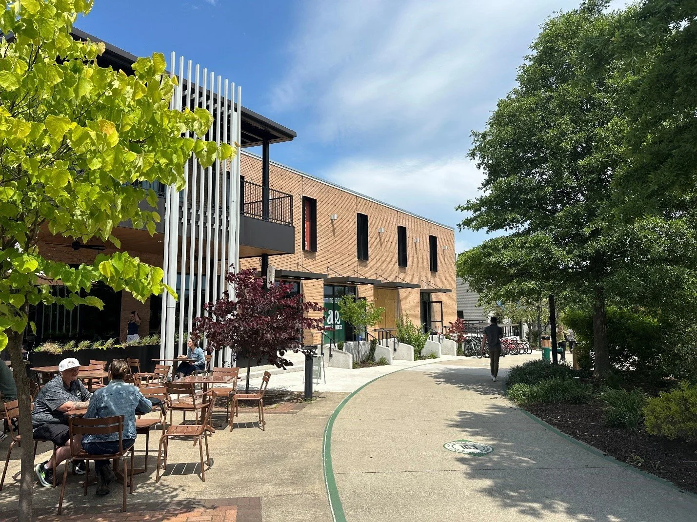
The Downtown Infill & Public Realm Core (Springdale):
Once an industrial-heavy agricultural center, Downtown Springdale showcases the economic power of trail planning. Because leaders insisted the trail cut through the town center, public realm investments triggered a massive wave of downtown housing and civic infrastructure explicitly oriented toward the trail system. A highlight for me on this tour was stepping into Onyx Coffee Lab (2026 #1 world-ranked coffee), which sits directly along the trail in downtown Springdale inside a beautifully repurposed historic industrial building.
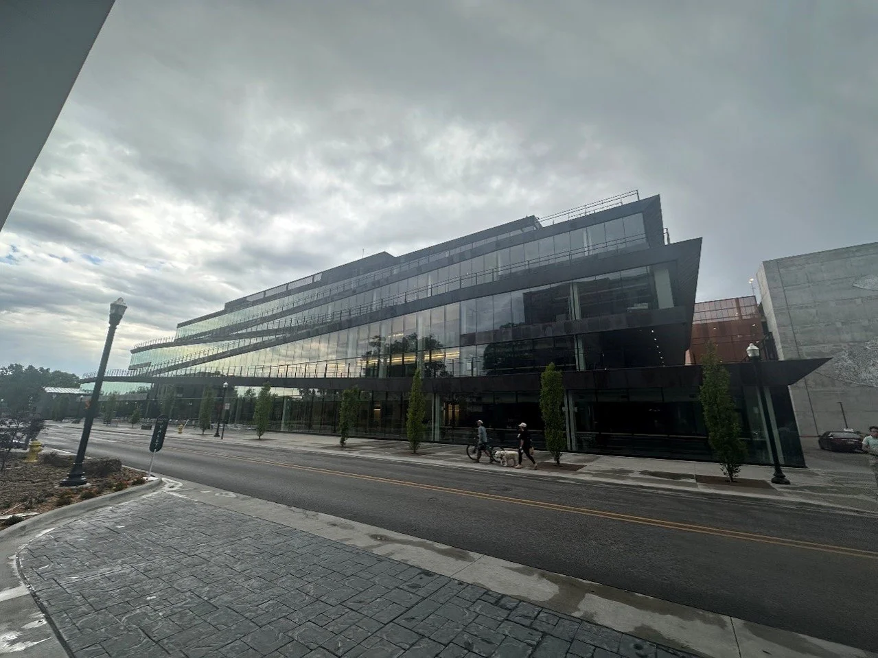
Active Transit as Eco-tourist engine (Bentonville):
Bentonville serves as a laboratory for aggressive bicycle infrastructure. It integrates active mobility directly into its high-density urban fabric (T6). After arriving at my hotel, I quickly became aware of how seriously this region takes cycling, as directly across the street from my hotel I stumbled across the world’s first fully bikeable multi-story office building – The Ledger by Marlon Blackwell Architects. This cycling mecca also boasts an extensive network of world-class mountain bike trails immediately (less than 1 mile) from the city center, which has quickly positioned Bentonville as a top destination iin the rapidly growing bike ecotourism industry. While not a mountain biker myself- I am an avid urban cyclist- I did rent a bike for an afternoon of fun directly from one of the many local shops that line the Bentonville streetscape, experiencing firsthand the joys of the “bike-in/bike-out” ecosystem per Bentonville’s marketing.
Applying TrOD to the Midwest
After a week seeing firsthand the successes of the TrOD planning framework, I am more convinced than ever that the lessons from NWA can apply to Midwestern cities. The three distinct takeaways are as follows:Bring the Trails Inward, Abandon the Periphery:
The Midwest is absolutely blanketed with thousands of miles of abandoned legacy rail corridors, many of which have been converted into recreational paths that loop around or bypass city centers to avoid conflict. Midwestern leadership must follow the NWA precedent: deliberately route or extend these trails straight through historic downtown blocks, commercial cores, and civic squares to activate high-value economic development where it matters most. In addition, trails need to be seen by local leaders as ALL of the following: recreational amenities, foundational transportation infrastructures, and economic development engines.
A Low-Cost Transit Alternative for Mid-Sized Metros:
For linear midwestern regions or industrial corridors (such as the Quad Cities, Northeast and Southwest Ohio, et.), the multi-million-dollar price tag of light rail is a financial non-starter. TrOD proves that a continuous bicycle-and-pedestrian spine cutting through consecutive town centers can anchor compact, walkable development at a fraction of the capital cost.
Overcoming Fractured Municipal Borders:
Midwestern regions are notorious for highly fragmented local governments competing for tax bases. The Greenway Transect provides a shared, cross-border regulatory framework. It allows adjacent cities to coordinate density, protect agricultural edges, and build a unified active-transportation network together, proving that progress can move seamlessly at a human scale.